

Urban plan for Porto Alegre waterfront
Projeto desenvolvido em conjunto com as arquitetas Christine Ozio, Natália Bassanesi e Nathalia Danezi.
Work developed with the architects Christine Ozio, Natália Bassanesi e Nathalia Danezi.
Work developed with the architects Christine Ozio, Natália Bassanesi e Nathalia Danezi.
O trabalho a seguir foi proposto pela disciplina de Urbanismo IV e tinha por objetivo propor medidas de intervenção planejada em espaço urbano específico. Ele desenvolveu-se em quatro módulos, onde os conteúdos relativos à análise, diagnóstico, estruturação e, especialmente, composição do espaço urbano em grande escala tiveram seu desdobramento teórico-prático.
The following work was proposed by the discipline of Urban IV and aimed to propose planned intervention to a specific urban space. It developed into four modules, where the approaches for analysis, diagnosis, structuring and especially composition of urban space on a large scale had split his theoretical and practical.
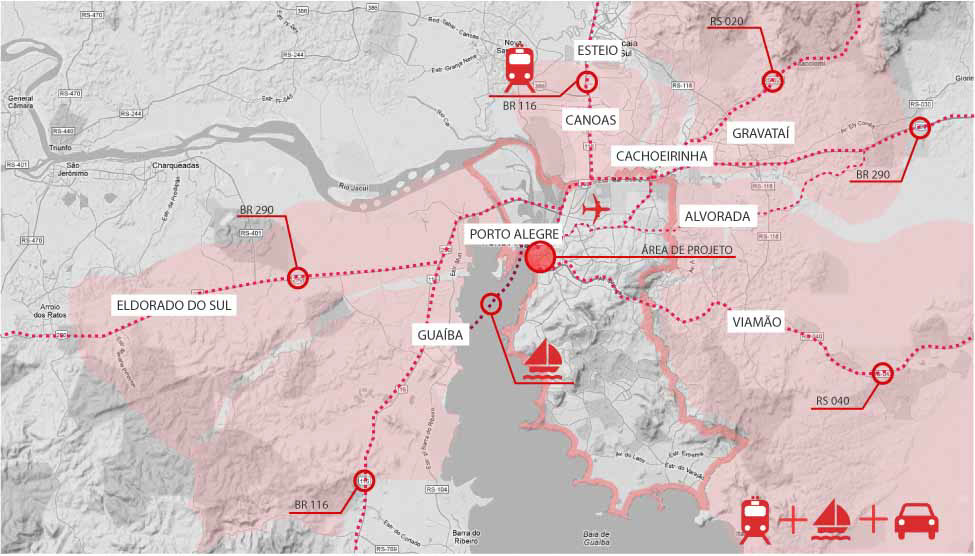
O local escolhido para o desenvolvimento do projeto da disciplina foi um trecho da orla da cidade de Porto Alegre (RS/BR). A fatia trabalhada começa no cais do porto da cidade e termina no início do Parque Marinha do Brasil. Essa área possui um elevado grau de acessibilidade e conectividade com o restante da cidade e com a região metropolitana. Sua conexão com os municípios da região metropolitana se dá pelos sistemas rodoviário (RS 040, BR 116 e BR 290), ferroviário através do Trensurb, e hidroviário utilizando-se a barca que conecta o cais do porto à cidade de Guaíba.
The venue for the development of the discipline project was a stretch of waterfront in Porto Alegre (RS / BR). The slice begins on the docks of the city and ends at the beginning of the Marina do Brasil Park. This area has a high degree of accessibility and connectivity with the rest of the city and the metropolitan region. Your connection with the municipalities of the metropolitan region is given by road systems (RS 040, BR 116 and BR 290), through Trensurb rail, and waterway using the ferry that connects the dock to the port city of Guaiba.

O trecho estudado localiza-se no centro de Porto Alegre, região mais antiga da cidade e que concentra grande número de edificações importantes para a urbe. Pela região passam vias de grande fluxo de veículos e que conectam o centro com os demais pontos da cidade. Ao longo da área de estudo verifica-se a variedade de tecidos urbanos característicos com o uso e função que cada pedaço desempenha.
The studied section is located in the downtown of Porto Alegre, the oldest part of the city and has a great number of important buildings for the metropolis. Routes of great traffic flow pass through the region and connect the center with other parts of the city. Throughout the study area there is a variety of typical urban fabric.

A partir da análise e diagnóstico da fatia a ser trabalhada, desenvolveu-se o programa do projeto, de acordo com as reais necessidades da capital, pensando em sua abrangência local e regional. Lançou-se o programa sobre o mapa da cidade, definindo-se assim o zoneamento, as conectividades e interações da área.
From the analysis and diagnosis of the slice to be imaged, the program design was developed in accordance with the actual needs of capital, considering its local and regional coverage. Launched the program on the city map, thus defining the zoning, connectivities and interactions of the area.

O projeto qualifica os espaços da orla da cidade e cria novos usos para região, devolvendo para os porto alegrenses essa área tão valoroza da capital.
Algumas das principais propostas do projeto:
- criação de marina pública;
- criação de passeio peatonal junto ao rio Guaíba, com bares, lojas e restaurantes;
- consolidação de parte da orla como praia;
- conecção de todo o percurso da orla através de ciclovia, calçada e trem leve;
- requalificação do parque existente Maurício Sirotsky Sobrinho com novo desenho paisagístico e novos usos;
- criação de passagens subterrâneas conectando a orla com parque;
- implantação do teatro da OSPA (Orquestra Sinfônica de Porto Alegre) próximo ao rio e ao tecido urbano consolidado do centro da cidade;
- requalificação do prédio da Usina do Gasômetro e arredores, o fazendo parte integrante da Escola de CInema de Porto Alegre;
- mergulho de trecho da Avenida Mauá e retirada do muro com mesmo nome da avenida, permitindo maior permeabilidade visual e urbana entre o centro e a orla.
The project qualifies spaces from edge of town and creates new uses for the region , returning to the people os Porto Alegre this area of the capital that is so valuable.
Some of the key proposals of the project :
- Creation of public marina;
- Creation of pedestrian promenade along the Guaiba River , with bars , shops and restaurants;
- Consolidation of a stretch of the waterfront as beach;
- Connection of the entire journey of the waterfront through bike path , sidewalk and light rail;
- Upgrading of existing Mauricio Sirotsky Sobrinho park with new landscaping design and new uses;
- Creation of underground passages connecting the waterfront with the park;
- Implementation of the OSPA theater ( Symphonic Orchestra of Porto Alegre ) near the river and the consolidated urban fabric of downtown;
- Upgrading the building of Usina do Gasômetro and surroundings, forming an integral part of film school in Porto Alegre;
- Dip stretch of Avenue Maua and removal of the wall with the same name of the avenue , enabling more visual and urban permeability between downtown and the waterfront.

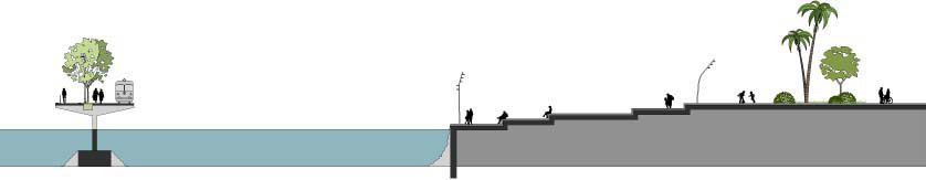
Corte da praia, do deck e da passagem subterrânea que leva ao parque.
Section of the beach, deck and underground passage that leads to the park.

Corte do deck e bares na orla.
Section of the deck and bars on the waterfront.

Corte do playground no parque.
Section of the playground in the park.
Corte da escada / arquibancada para o rio e da via sobre o rio Guaíba.
Section of the stairs / bleachers to the river and the route on the Guaiba River.


